
When people talk about rising seas, the conversation almost always centres on melting glaciers and warming oceans. But there is another piece of the puzzle that rarely gets the attention it deserves: the land under many of the world's biggest coastal cities is actually sinking. And when you combine that with rising oceans, the result is flooding risk that is escalating far faster than most climate models suggest.
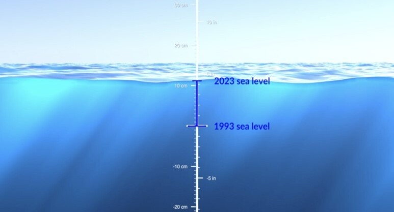
A team of researchers from the Technical University of Munich's German Geodetic Research Institute (DGFI-TUM), working with scientists from Tulane University, decided to dig into just how big this problem really is. What they found, published recently in Nature Communications, is striking: in densely populated coastal areas, sea levels relative to the land are climbing by about 6 millimetres a year on average. That is nearly double what you would expect from climate change alone, and about three times the global average once you consider the number of people who actually live along coastlines.
The figure that matters
About 6 mm a year of relative sea-level rise in densely populated coastal areas — roughly double what climate change alone would produce.
What is causing the ground to sink?
There is no single explanation; it is usually a mix of things. Cities that pump too much groundwater out of the earth are often the biggest offenders, but oil and gas drilling plays a role too, as does the natural settling of soft, sediment-rich soil in river deltas. Even the weight of skyscrapers and dense urban infrastructure can push land downward over time. Add in slower-moving forces like tectonic activity and the land's ongoing adjustment since the last Ice Age, and you get a genuinely complicated picture.
Julius Oelsmann, who led the study, put it simply: if we only watch the ocean, we are missing half the story. He says that in crowded coastal cities, it is often human activity — draining aquifers, pulling resources from underground — that is making the land drop faster. Pile the weight of a growing city on top of that, along with slow geological shifts, and you end up dramatically amplifying whatever sea-level rise climate change is already causing.
Where it is worst
Some countries are dealing with this far more than others. Thailand, Bangladesh, Nigeria, Egypt, China, and Indonesia all show population-weighted rates of roughly 7 to 10 millimetres a year. The U.S., the Netherlands, and Italy are not far behind, sitting around 4 to 5 millimetres annually.
Look at specific cities and the numbers get even more dramatic:
- Jakarta — averaging 13.7 mm a year, though some neighbourhoods are sinking by a staggering 42 mm annually
- Tianjin — 13.5 mm a year
- Bangkok — 8.5 mm a year
- Lagos — 6.7 mm a year
- Alexandria — 4 mm a year
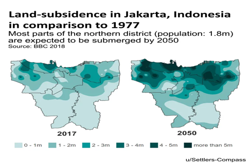
Jakarta is a particularly good example of how uneven this can get: parts of the city are dropping fast while other pockets are actually holding steady or rising slightly.
Interestingly, not every coastline is losing the battle. In Sweden and Finland, the land is still rebounding from the weight of Ice Age glaciers that melted thousands of years ago, and it is rising faster than the sea — so relative sea levels there are actually falling.
The good news
Unlike global warming, subsidence is something local governments can actually do something about. Florian Seitz, who directs DGFI-TUM, points out that because groundwater overuse is usually the main driver in big cities, smarter water policy can make a real dent — things like tighter limits on pumping, or actively recharging aquifers.
Tokyo is proof this works. The city once sank by more than 10 centimetres a year, with some areas dropping nearly 24 centimetres annually at the worst of it. Government intervention and a switch to alternative water sources turned that around. Texas offers a similar success story: after heavy groundwater pumping caused serious subsidence around Houston and Galveston, the state created the Harris-Galveston Subsidence District back in 1975 to regulate water use, and it has made a real difference.
Why this matters
None of this is entirely new to scientists who study coastlines; hydrologists and geologists have flagged subsidence as a serious issue for years. But this research puts hard numbers behind something that is easy to overlook. Consider that climate-driven sea-level rise globally runs around 2 to 4 millimetres a year. In cities like Jakarta, or in Tokyo decades ago, subsidence has outpaced that figure by ten times or more.
That is a sobering reminder: if coastal cities only plan for rising oceans and ignore what is happening beneath their own streets, they are likely underestimating how bad flooding could get.
References
Oelsmann, J., Nicholls, R. J., Lincke, D., Marcos, M., Shirzaei, M., Sánchez, L., Ohenhen, L., Dettmering, D., Hinkel, J., Horton, B. P., & Seitz, F. (2026). Subsidence more than doubles sea-level rise today along densely populated coasts. Nature Communications. DOI: 10.1038/s41467-026-72293-z
Technical University of Munich (TUM), German Geodetic Research Institute (DGFI-TUM), research communications, July 2026.
حين يتحدث الناس عن ارتفاع منسوب البحار، ينصبّ التركيز غالبًا على ذوبان الأنهار الجليدية وارتفاع حرارة المحيطات. لكن هناك جانبًا آخر من هذه المعضلة نادرًا ما يحظى بالاهتمام الذي يستحقه: فالكثير من المدن الساحلية الكبرى في العالم بدأت فعليًا في الهبوط. وحين يجتمع هذا الهبوط مع ارتفاع مستوى المحيطات، تتصاعد مخاطر الفيضانات بوتيرة أسرع بكثير مما تتوقعه نماذج المناخ.
قام فريق من الباحثين في المعهد الألماني للأبحاث الجيوديسية التابع لجامعة ميونخ التقنية (DGFI-TUM)، بالتعاون مع علماء من جامعة تولين، بالتعمّق في هذه المشكلة لمعرفة حجمها الحقيقي. وما توصّلوا إليه، والمنشور مؤخرًا في مجلة Nature Communications، كان لافتًا: ففي المناطق الساحلية كثيفة السكان، يرتفع منسوب البحر النسبي بمعدل يقارب 6 ملم سنويًا. وهذا الرقم يقارب ضعف ما كان متوقعًا حدوثه نتيجة للتغيّر المناخي وحده، ويعادل تقريبًا ثلاثة أضعاف المعدل العالمي إذا أخذنا في الاعتبار التوزيع السكاني على السواحل.
الرقم الأهم
نحو ٦ ملم سنويًا من الارتفاع النسبي لمنسوب البحر في المناطق الساحلية كثيفة السكان — أي ما يقارب ضعف ما يُحدثه التغيّر المناخي وحده.
ما الذي يجعل الأرض تهبط؟
لا يوجد تفسير واحد لظاهرة هبوط الأراضي، بل هو في الغالب مزيج من عوامل. فالمدن التي تفرط في ضخّ المياه الجوفية إلى السطح غالبًا ما تكون الأكثر تضرّرًا، إلى جانب عمليات التعدين واستخراج النفط والغاز، وكذلك الترسّب الطبيعي للتربة الرخوة الغنية بالرواسب في دلتا الأنهار. حتى وزن البنايات الضخمة وناطحات السحاب والبنية التحتية للمدن الكثيفة يمكن أن يدفع الأرض إلى الهبوط مع مرور الوقت. وبإضافة حركة الصفائح الأرضية واستمرار تكيّف سطح الأرض منذ نهاية العصر الجليدي الأخير — وهي عوامل بطيئة مقارنة بغيرها — نحصل على صورة أكثر تعقيدًا.
ويلخّص يوليوس أولسمان، الباحث الرئيسي لهذه الدراسة، الأمر قائلًا: «إذا اكتفينا بمراقبة المحيط فقط، فإننا نتجاهل نصف القصة». ويوضّح أن النشاط البشري — كاستنزاف مخزون المياه الجوفية واستخراج الموارد من باطن الأرض — هو غالبًا ما يجعل الأرض تهبط بسرعة أكبر، خاصة في المدن الساحلية المزدحمة. وإذا أضفنا إلى ذلك سرعة التوسّع العمراني، إلى جانب التغيّرات الجيولوجية البطيئة، فإن ارتفاع منسوب مياه البحر سيكون أكبر بكثير من تأثير التغيّر المناخي وحده، إذ يرتفع منسوب المياه وتهبط الأرض في الوقت نفسه.
المدن الأكثر تضرّرًا
بعض الدول تعاني بالفعل من هذه الظاهرة أكثر بكثير من غيرها. فتايلاند وبنغلاديش ونيجيريا ومصر والصين وإندونيسيا تسجّل جميعها معدّلات مرجّحة سكانيًا تتراوح بين 7 و10 ملم سنويًا تقريبًا. أما الولايات المتحدة وهولندا وإيطاليا فليست بعيدة عن ذلك، إذ تسجّل نحو 4 إلى 5 ملم سنويًا.
وإذا نظرنا إلى مدن بعينها، تصبح الأرقام أكثر إثارة للقلق:
- جاكرتا — بمعدل 13.7 ملم سنويًا، رغم أن بعض الأحياء تهبط بمعدل مذهل يبلغ 42 ملم سنويًا
- تيانجين — 13.5 ملم سنويًا
- بانكوك — 8.5 ملم سنويًا
- لاغوس — 6.7 ملم سنويًا
- الإسكندرية — 4 ملم سنويًا
وتُعدّ جاكرتا مثالًا واضحًا على مدى التفاوت الذي يمكن أن يحدث داخل المدينة الواحدة؛ إذ تهبط بعض الأجزاء بسرعة بينما تظل أجزاء أخرى مستقرة بل وقد ترتفع قليلًا.
ومن اللافت أن ليست كل السواحل خاسرة في هذه المعركة. ففي السويد وفنلندا، ما زالت الأرض ترتفع تدريجيًا نتيجة ذوبان الأنهار الجليدية التي كانت تثقلها منذ آلاف السنين في العصر الجليدي، وترتفع بمعدل أسرع من ارتفاع منسوب البحر، ما يجعل المنسوب النسبي للبحر هناك في تراجع فعلي.
الخبر الجيد
على عكس الاحتباس الحراري العالمي، فإن هبوط الأرض أمر يمكن للحكومات المحلية أن تتصدى له بشكل أكثر فعالية. ويشير فلوريان زايتس، مدير المعهد الألماني للأبحاث الجيوديسية، إلى أنه بما أن الإفراط في استخدام المياه الجوفية هو غالبًا السبب الرئيسي لهبوط الأراضي في المدن الكبرى، فإن سياسات إدارة المياه الأكثر ذكاءً يمكن أن تُحدث فرقًا حقيقيًا، مثل فرض قيود أشدّ على ضخّ المياه الجوفية أو التشديد على إعادة تغذية طبقات المياه الجوفية بشكل فعّال.
وتُعدّ طوكيو دليلًا حيًا على نجاح هذا النهج. فقد كانت المدينة تهبط بأكثر من 10 سنتيمترات سنويًا في السابق، ووصل الهبوط في بعض المناطق الأكثر تضرّرًا إلى نحو 24 سنتيمترًا سنويًا في أسوأ حالاته. لكن تدخّل الحكومة والتحوّل إلى مصادر مياه بديلة غيّرا مسار الأمور تمامًا. وتقدّم ولاية تكساس قصة نجاح مماثلة؛ فبعد أن تسبّب الإفراط في ضخّ المياه الجوفية بهبوط ملحوظ في منطقتَي هيوستن وغالفستون، أنشأت الولاية «منطقة هاريس-غالفستون لمكافحة الهبوط الأرضي» عام 1975 لتنظيم استخدام المياه، وقد أحدثت فرقًا حقيقيًا.
لماذا يهمّ هذا الأمر؟
هذه الظاهرة ليست جديدة تمامًا على العلماء المتخصّصين في دراسة السواحل، فقد حذّر خبراء المياه الجوفية والجيولوجيا من مشكلة الهبوط الأرضي منذ سنوات. لكن هذه الدراسة تضع أرقامًا دقيقة لمسألة كان من السهل جدًا تجاهلها. فإذا علمنا أن الارتفاع العالمي لمنسوب البحر الناتج عن التغيّر المناخي يتراوح بين 2 و4 ملم سنويًا فقط، نجد أن الهبوط الأرضي في مدن مثل جاكرتا، أو في طوكيو قبل عقود، قد تجاوز هذا الرقم بعشرة أضعاف أو أكثر.
وهذا تذكير مهم: فإذا اكتفت المدن الساحلية بالتخطيط لمواجهة ارتفاع المحيطات وحده، متجاهلةً ما يحدث تحت شوارعها، فمن المرجّح أنها تقلّل من تقدير حجم مخاطر الفيضانات المقبلة ومن جاهزيتها للتصدي لمثل هذه الأزمات.
المراجع
Oelsmann, J., Nicholls, R. J., Lincke, D., Marcos, M., Shirzaei, M., Sánchez, L., Ohenhen, L., Dettmering, D., Hinkel, J., Horton, B. P., & Seitz, F. (2026). Subsidence more than doubles sea-level rise today along densely populated coasts. Nature Communications. DOI: 10.1038/s41467-026-72293-z
جامعة ميونخ التقنية (TUM)، المعهد الألماني للأبحاث الجيوديسية (DGFI-TUM)، بيانات صحفية بحثية، يوليو ٢٠٢٦.